Latest Update
Full Trail Report
Our fellow runner Andrew Cox completed a hike of the full Gabrielino Trail this past weekend, Jan 17-18. He wrote a very informative report about the trail conditions, including hazards and things ...
View all updates →Join us for a scenic 50K trail run through the beautiful San Gabriel Mountains!
Event Details
- Date: Saturday, March 28th, 2026
- Starting Point: Chantry Flats parking area
- Post-Run: Picnic at Brookside Park
Schedule
- 6:00 AM Meet at Brookside Park. Hand over drop bags to aid station crew.
- 6:15 AM Depart for Chantry Flat
- 6:45 AM Arrive at Chantry Flat
- 7:00 AM Start running
Route
Specs
- Strava Route
- CalTopo Route
- Download GPX
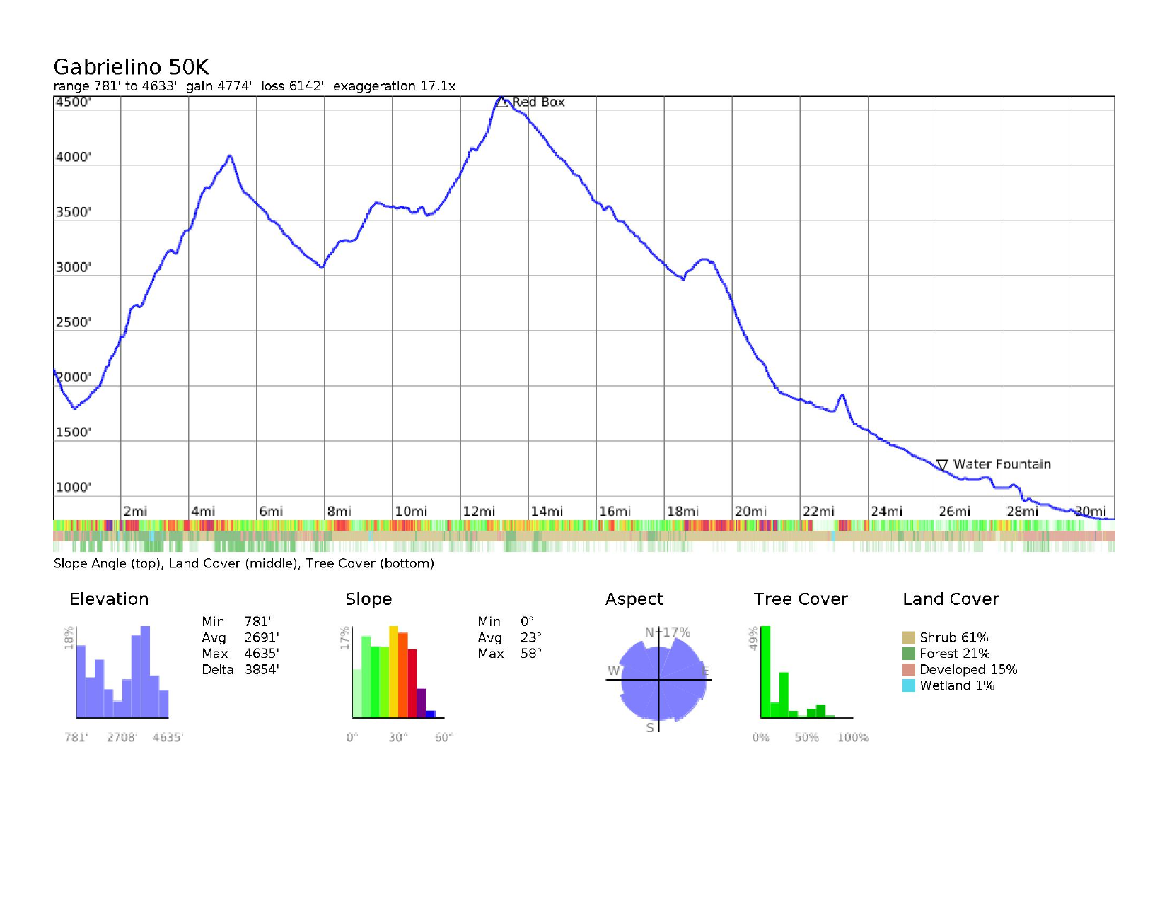
- Distance: 31.5 miles
- Vertical: 4700 ft (according to Strava)
- Aid Stations: We will have an aid station at Red Box with water and drop bags.
Description
The run starts at Chantry Flats and follows the Gabrielino trail through the Angeles National Forest, where it emerges in Altadena near the Jet Propulsion Laboratory. We’ll keep going from there south past the Rose Bowl to Brookside Park for a celebratory picnic.
Notes:
- You can take either the upper or lower trail at the split before Sturtevant Falls.
- The condition of the trail after Newcomb Pass is uncertain. We are trying to get more information and will update this site based on what we find.
- The distance and elevation are from Strava, which tends to be somewhat inaccurate. We won’t have better information until we complete the run.
Landmarks
Mileage numbers are approximate!
| Landmark | Distance (miles) | Notes |
|---|---|---|
| Start | 0 | Start at the gated fire road by the bathrooms at the lower parking lot. The fire road descends immediately. |
| Winter Creek | 0.6 | The fire road turns into a trail. Cross a rickety bridge over Winter Creek. A small signed trail goes off to the left up Winter Creek. Stay on the main trail as it follows Sturtevant Creek up the bottom of the canyon. |
| Fern Lodge Junction | 1.4 | Reach a 4-way junction. Take the left-most trail. This is the upper portion of the Gabrielino Trail. The middle trail takes you to the top of Sturtevant Falls along the lower portion of the Gabrielino Trial, and then up a narrow canyon with several small waterfalls and pools. These two trails rejoin at 3.7 miles if you take the upper trail, and 3.3 miles if you take the lower trail. The lower trail is more technical, but scenic. Recommend the upper trail for an easier overall run - mileage shown beyond this point assumes the upper trail was taken. If you stay right at Fern Lodge Junction, the trail dead ends at Sturtevant Falls after 0.2 miles. |
| 2.5 | The upper and lower trails rejoin. There is a sign. Stay to the left on the high trail. | |
| Spruce Grove Trail Camp | 3.3 | Reach a small shaded campground. There is a pit toilet. |
| 3.6 | Turn right at the sign for the Gabrielino Trail and Newcomb Pass. If you reach Sturtevant Camp (several cabins and a swing), you missed the turn. The Gab climbs gradually through forest for about 0.5 miles, then you transition into a more expossed chaparral and the trail climbs more steeply for about a mile before rounding a ridge. Newcomb Pass comes into sight, but is still another 0.5 miles away. The rest of the way to Newcomb Pass is wooded once more. | |
| Newcomb Pass | 5.5 | Reach a 4-way junction at the saddle (6-way if you count the fire break). Take the rightmost trail. This isn’t the Gabrielino Trail, but is recommended for an easier run - mileage shown beyond this point assumes you turned right. The actual Gabrielino Trail continues straight, but is so badly overgrown that you will be orienteering off-trail until you reach the fire road, a rough quarter mile or so straight down through the jungle. |
| Water Tank | 6.1 | At the concrete water tank, the trail ends at a T-intersection with Rincon-Red Box Road, a dirt fire road. Turn left and begin your first long descent of the run. |
| Old Trail Sign | 6.8 | After descending on the fire road through the woods, find a decaying sign for the Gabrielino Trail. If you bushwacked from Newcomb Pass, you should emerge onto the fire road here. Continue on the fire road. |
| West Fork Trail Camp | 9.2 | Just past the campground, turn left onto a singletrack trail (the Gabrielino Trail again). From here, both the Gabrielino Trail, and the fire road will take you to Red Box (our aid station). Mileage shown beyond this point assumes you took the Gabrielino Trail. The fire road is a good option if you are running out of gas and need to get to Red Box sooner, although it is exposed to the sun for most of the next 5.5 miles. The Gabrielino Trail takes 5.3 miles to reach Red Box, but is slower than the fire road because of technical trail, overgrowth, and changing creekbeds. |
| 10.7 | !!! After climbing steadily through the chaparral for 1.5 miles, there is a very easy turn to miss. The trail parallels a creek below to the right. Look for a faint trail that turns right and drops down to cross the creek. This is an important point to keep your eyes on your GPS. If you miss the turn, the next waypoint is the top of Mt. Wilson(!), 3.2 miles and 2100 vertical feet later. | |
| Valley Forge Trail Camp | 12.2 | After some exposed, and likely overgrown, but fairly level singletrack, reach a faint trail to the left, and shortly thereafter another side trail on the right. Stay straight through both of these options. The first left takes you to the top of Mt. Wilson (again, you don’t want to do that), the right hand option takes you to Valley Forge Trail Camp, which has historically had a pit toilet, but no promises. The Valley Forge turnoff will also reconnect you with Rincon-Red Box Road if you need a bail out from the likely overgrown singletrack. Mileage beyond this point assumes you stayed on the Gabrielino Trail. Beyond Valley Forge there are stretches where the trail crosses the creek (West Fork San Gabriel River) where it can be difficult to follow because of wash outs and overgrowth. Stay the course carefully. Be especially careful for Poison Oak, this is one of its favorite spots, among many. You will reach an opening with ruins of a cabin and a partially subterranean shed. Aim slightly right of the shed. |
| Camp Hi-Hill | 13.6 | The trail gets a bit faint as you approach Camp Hi-Hill. Some buildings can be seen off the trail to the left. Stay right. |
| 13.8 | The trail crosses Rincon-Red Box Road at an open clearing. The Gabrielino Trail continues straight across the fire road, but isn’t immediately apparent. | |
| Red Box (Aid Station) | 14.5 | Switchback up through intermittent shade and sun and tiny side canyons that might still have a trickle of flowing water until you reach Red Box. After availing yourself of your drop bag and some friendly volunteer aid station love, cross through the parking lot, cross Mt. Wilson Red Box (paved) Road and another parking lot before dropping down to continue on the Gabrielino Trail. This is the high point of the run! It’s all (almost) downhill from here. |
| Switzer Picnic Area | 18.7 | The trail descends steadily. What a relief. There are no significant side trails until you reach Switzer Picnic Area. There is at least one spot on the way where winter rains make a creek crossing difficult to follow. Stay aware and know that you are now following the Arroyo Seco downstream. If you are running upstream, you are going the wrong way. Follow the creek downstream through the picnic area, briefly running downhill through the parking lot. Turn left across a bridge before the parking lot access road turns uphill to the right. Continue downstream past the pit toilets at 19 miles (use at your own risk). |
| 20 | After many rock-hopping and/or shallow wading creek crossings reach a clearing with old-timey, rusted camping stoves on your left. The trail then crosses the creek to the right and immediately begins switchbacking up the canyon wall. | |
| Bear Canyon Trail junction | 20.2 | The trail quickly climbs high above the canyon bottom (and Switzer Falls). At 20.2ish reach a junction with a prominent trail sign. Turn right on the high trail towards Altadena. |
| Long Canyon Falls | 23.1 | Traverse the north rim of the Arroyo Seco’s Royal Gorge. About half a mile of trail is quite exposed before crossing a saddle and dropping down into shady Long Canyon. After a long descent full of poison oak, you reach the top of a waterfall. Shortly afterwards you must cross the Arroyo. Your shoes will get wet. |
| Ken Burton Trail junction. | 24.2 | The trail hugs the cliffs along the south bank of the Arroyo in the shade. Reach a signed junction with the Ken Burton Trail. Take the trail to the right to stay along the Arroyo. If you turn left you’ll end up climbing non-stop for 2 miles. |
| 24.4 | The trail seems to dead end into the creek. It continues faintly on the other side, slightly downstream. The trail is hot and exposed for the next half mile and difficult to follow. The winter rains washed away a few sections of trail, so you’ll have to pay extra close attention to footprints and bike paths as you slosh down the Arroyo. People often get turned around in this area, but as long as you are following the creek downstream, you’ll make it to the next turn. | |
| 24.8 | At 24.8ish the trail leaves the creekbed and climbs up the east side of the canyon. If you reach the top of a waterfall over a dam, you missed the trail by a few hundred meters. | |
| Above the dam | 25.1 | Finish your final climb of the run at a viewpoint overlooking Brown Mountain Dam and its waterfall. Its all downhill from here. |
| Paul Little junction | 25.4 | Descend steeply to a trail junction at a monument sign for Paul Little Picnic Area. Turn left and immediately cross the Arroyo. There will be about a dozen more water crossings, so your feet will stay wet, but it might be a nice escape from the sun. This is a popular stretch of trail, so watch out for large, slow-moving groups of hikers, mountain bikers, kids, and dogs. |
| Gould Mesa Trail Camp | 27.3 | Reach a trail junction at Gould Mesa Trail Camp. There is a pit toilet at the junction. Take the wide path to the left. Going right will take you up a fire road all the way to Angeles Crest Hwy. You don’t want to do that. |
| 27.5 | The trail splits, but either way takes you to the same spot with similar distance. Taking the trail to the right avoids two water crossings. People sometimes get turned around here, but again as long as you are following the Arroyo downstream you’ll stay on track. | |
| 27.6 | The trails rejoin. Continue downstream. | |
| Water fountain | 28.5 | The trail widens near some houses to your left. There is a stone water fountain on the left below a big oak tree. This is your last chance for water. |
| Brown Mountain sign | 28.6 | A paved trail heads up to the left. Continue straight. |
| Double decker bridge | 29 | The trail turns into a paved road. Cross a bridge on top of another bridge and immediately turn right on a trail that drops sharply from the road. If you miss this turn, no biggie. You’ll shortly see the large dirt parking lot below to your right. There are multiple options for getting down to the parking lot. NOTE: The GPX file just continues down the road bypassing the big parking lot. Just after it reaches a stop sign, there’s a small parking area on the right with a trail that connects back to the point at mile 29.8. Both routes are fine. |
| JPL dirt lot | 29.2 | After a short rocky jaunt along the creek, emerge from the trail into the wide open dirt parking lot. |
| 29.6 | Run through the massive parking lot. At the very far south end of the lot, join the paved access driveway, then quickly turn right onto a road with a closed gate. | |
| 29.8 | Turn left onto a side trail just before a small building on the left. This trail rejoins the road at Devil’s Gate Dam. Both routes are the same distance, but the trail is a bit shadier. | |
| Devil’s Gate Dam | 30.5 | Arrive at a paved road that crosses the top of the dam to your right. Look for a dark tunnel ahead and slightly to the right. The tunnel takes you under Oak Grove Drive. |
| 30.7 | After the tunnel, the trail drops down a long set of stone steps and reaches an open clearing. Go right through the clearing and immediately rock hop across the Arroyo. | |
| Parkview Ave | 31.5 | Follow the trail beneath the 210 freeway that towers high above. The trail follows the edge of Brookside Golf Course until reaching a crosswalk at Parkview Ave. |
| Salvia Canyon Rd | 32.1 | Cross the crosswalk and join a small trail that parallels West Drive and more golf course. You can join the masses of runners and cyclists on the road as they do the Rose Bowl Loop, but the trail has a little more shade, which will be in high demand by this point. Reach another crosswalk at Salvia Canyon Road and continue across to more trail. |
| Rose Bowl and Seco Street | 32.8 | The trail continues to parallel the Rose Bowl Loop, and the Rose Bowl itself to your left. The trail disappears into a wood chipped parking area. Continue along the road until you reach an intersection with Seco Street. Turn left and cross over the Arroyo, now in a concrete channel. This is a busy intersection - watch out for cars, bikes, runners, etc. Immediately after crossing the channel turn right onto a dirt trail that parallels the channel. |
| 33 | Leave the trail and cross Arroyo Blvd into the large parking lot. | |
| Finish! | 33.4 | Run through the park, going around the baseball fields, tennis courts, and finally find the finish line at the picnic area behind the pool near the Pirate Park. Yaaaar. Keep watching out for poison oak here, you never know where you’ll find it! |
Elevation Profile
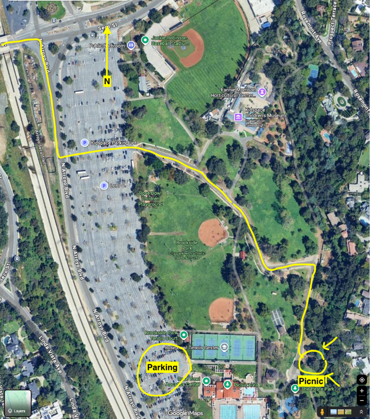
Finish
Below you will see a diagram of the very end of the route leading to the picnic. I’ve highlighted the route I plan to follow, but the main thing is just get to the picnic area. I’ve also circled the area we should park when we meet up in the morning. For those of you that have never been here, use “Rose Bowl Aquatics Center” as your GPS destination.
Safety
- This is a community run, not an organized race
- Participants are responsible for their own safety and navigation
- Bring adequate water and nutrition
- Know your limits and turn back if needed
- Trail conditions can vary - check recent reports before the run
Contact
If you are interested in participating, either to run or help out, please send us an email.
Contact: gab50k@pm.me
This is a community-organized trail run. Participate at your own risk.